Project Overview
Welcome to the ACCELERATE project. ACCELARATE pioneers next-gen environmental monitoring to protect ecosystems, cities, and culture in the face of climate change.
About
ACCELARATE is a forward-looking research project dedicated to advancing the role of Unmanned Aerial Vehicles (UAVs) in fostering environmental sustainability. In an era where climate change poses escalating threats to ecosystems, societies, and cultural heritage, ACCELARATE seeks to unlock the full potential of UAV-based monitoring systems as precise, flexible, and scalable tools for environmental observation.
Combining UAV technology with Artificial Intelligence (AI), the project addresses current limitations in Earth Observation, such as inadequate spatial resolution, limited real-time capabilities, and the absence of standardized, open-source tools. ACCELARATE explores innovative applications across diverse domains—urban areas, agriculture, coastlines, and cultural landscapes—aligning with key EU priorities such as the European Green Deal, the new European Bauhaus, and climate neutrality objectives.
By tackling key challenges—ranging from AI integration and data processing to operational constraints like battery life and weather conditions—ACCELARATE is paving the way for a new era of sustainable environmental monitoring. The project promotes interdisciplinary collaboration, laying the groundwork for data-driven, adaptive, and inclusive strategies that support resilient ecosystems and communities.
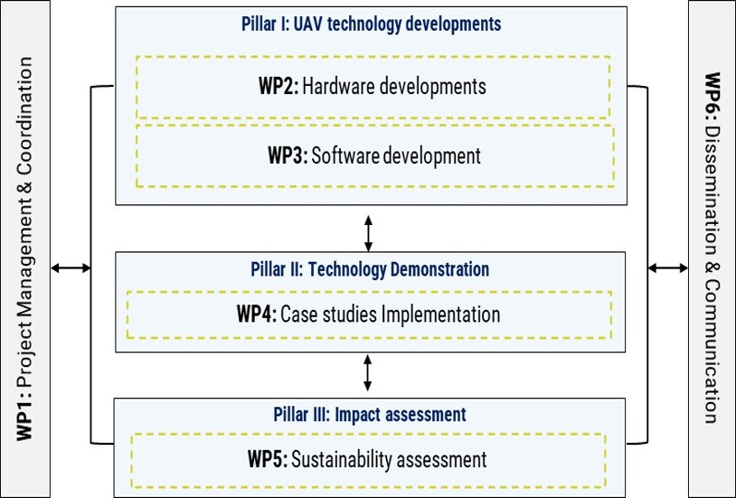
ACCELERATE Work Packages
Project's Specific Objectives & Key Performance Indicators
SO1 (achieved by WP2)
Carrying out state-of-the-art technological advancements of UAVs including hardware components and open-source software tools to enable a more efficient and cost-effective collection and analysis of UAVs in sustainability assessment studies.
- KPI 1: >1 hardware prototype (blueprint)
- KPI 2: >1 open source software tool
SO2 (achieved by WP3)
Demonstrating UAV technological advancements in real-world scenarios across various disciplines. All results available via repositories and sharing platforms, providing a wealth of data to the global community at a single point of reference.
- KPI 3: >1 open dataset hosted in the project’s repository
SO3 (achieved by WP3,4)
Delivering new guidelines and establishing protocols for conducting comprehensive sustainability assessment and assessing cutting-edge technological developments in the field of UAVs, to support decision making toward climate adaptation.
- KPI 4: >1 document focusing on UAV data acquisition guidelines
SO4 (achieved by WP2,3,4)
Sharing multidisciplinary knowledge and the know-how among the partners, while aligning different scientific cultures for the integration of knowledge from the UAVs to decision making in sustainable environmental management.
- KPI 5: >1 training webinar/workshop
SO5 (achieved by WP2,3,4)
Promoting skills and careers of the exchanged staff via the adoption of innovative training methods. The seconded staff will be re-integrated to the sending companies/institutes to acquire and enhance their skills and knowledge.
- KPI 6: >1 internal training webinar/workshop
SO6 (achieved by WP6)
Disseminate and communicate ACCELERATE results to scientists, industry, UAV operators and society. Engage the public through interactive networking events and 2 workshops to communicate resilience and environmental sustainability within the EU using data science and emerging UAV technologies.
- KPI 7: >5 events linked with dissemination and communication activities