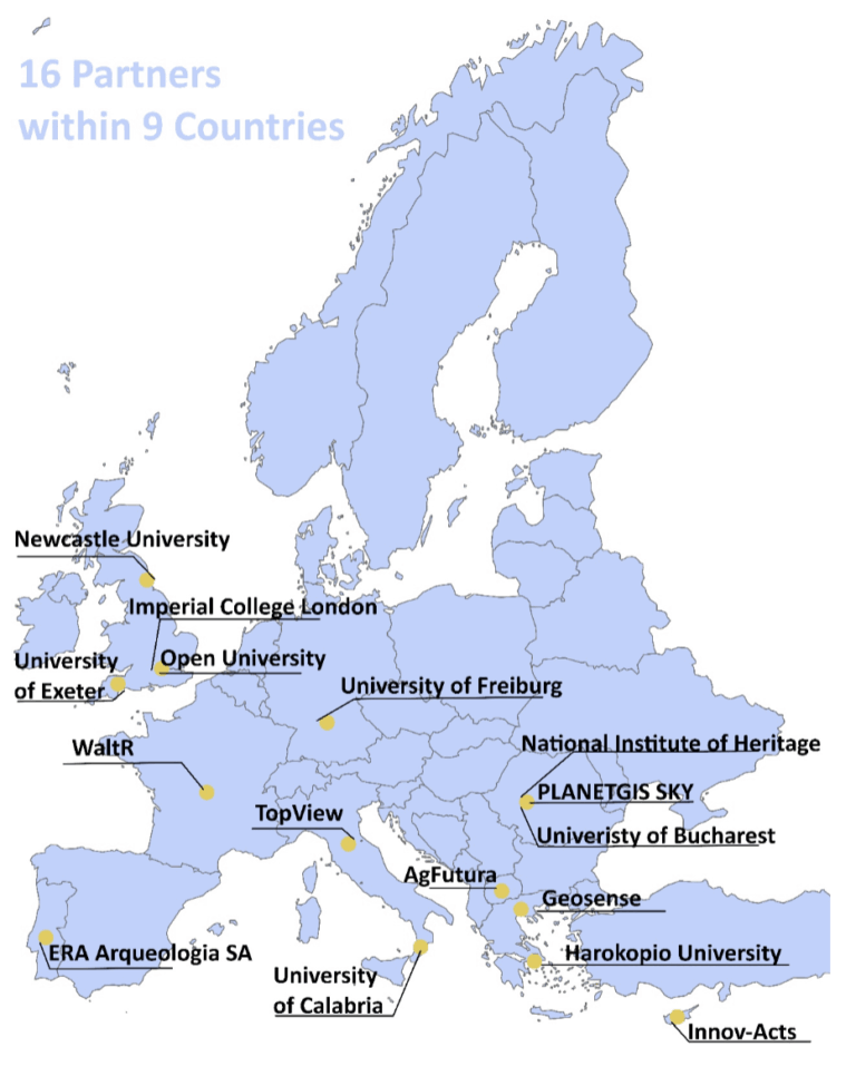
Harokopio University of Athens
Greece
Project coordinator leading UAV development, coordination, dissemination, use case implementation, and socioeconomic impact assessment.
GEOSENSE
Greece
Specializes in UAV hardware and remote sensing. Leads Work Package 2 and develops BVLOS systems, telemetry, and environmental monitoring platforms.
ERA Arqueologia SA
Portugal
Expert in archaeological UAV remote sensing, leading Use Case 4 with high-resolution UAV documentation of cultural heritage landscapes.

Innov-acts
Cyprus
Leads UAV software architecture and development. Participates in all WPs and drives end-user requirement gathering and systems design.
Newcastle University
United Kingdom
Contributes to sustainability assessment frameworks using UAVs. Brings long-standing expertise in interdisciplinary research.

WaltR
France
Experts in remote sensing technologies for emissions and atmospheric pollution. Leads efforts in air pollution monitoring, DL modelling, and environmental impact evaluation of our use cases.
AgFutura Technologies
North Macedonia
Drives Use Case 2 on precision agriculture. Provides smart farming solutions and contributes to impact assessment and tool development.
University of Freiburg
Germany
Offers expertise in geoinformatics, deep learning, and drone image analysis platforms. Supports AI-based vegetation and biodiversity monitoring.

University of Exeter (UNEXE)
England
Applies remote sensing to archaeology and cultural heritage. Supports testing of ACCELERATE’s framework at experimental sites in Romania and the Iberian Peninsula.

Imperial College London (ICL)
England
Develops Environmental Impact Assessment (EIA) methods. Evaluates the added value of UAV-based monitoring for sustainability and resource management.

National Institute of Heritage (NIH)
Romania
Manages Romania’s national cultural heritage databases. Brings expertise in digitization, remote sensing, and archaeological data for heritage protection.

University of Calabria
Italy
Provides academic expertise in drone-based sensing and data analytics. Supports AI research and contributes to methodological development in Use Case 3.
TopView
Italy
Drone technology company with expertise in UAV platforms for agriculture and environmental monitoring. Supports system integration and testing.
University of Bucharest (UB)
Bucharest
The University of Bucharest (UB), founded in 1864 by Prince Alexandru Ioan Cuza, is one of Romania’s leading research institutions. With over 50 research institutes collaborating internationally, it holds a top position in Romanian academia and ranks among the world’s best universities according to the QS World Rankings.

The Open University (OU)
UK
The Open University (OU), based in the United Kingdom, is a world leader in distance learning and innovative research. With a strong focus on accessibility, interdisciplinary collaboration, and societal relevance, OU combines academic excellence with real-world impact across a range of sectors including education, science, technology, and social sciences.

PlanetGIS Sky
Romania
PlanetGIS Sky is a specialized company in geospatial technologies, offering cutting-edge solutions in remote sensing, UAV-based data collection, and geographic information systems (GIS). With a focus on innovation and field-based applications, the company supports decision-making in areas such as environmental monitoring, precision agriculture, and infrastructure management.